The Neighborhood We Call Home
Welcome to Wheat Ridge, CO, a place perfectly situated between the city and foothills. Enjoy access to shops and restaurants, and live walking distance from transport and parks.
Wheat Ridge, CO
UBICACIÓN DESTACADA
-
3.5 acres En Wheat Ridge en 44th justo al este de 1-70 y al oeste de Kipling
-
A una cuadra de Clear Creek Trail (19 millas)
-
Frente a Prospect Park: 39 acres con pickle ball, refugios para pícnic, paseo marítimo de pesca, campo de fútbol, etc.
-
Frente a dos hermosos estanques
-
A menos de una milla de la parada del tren ligero G Line
-
La ciudad está en marcha en el Plan de Subárea 44


VIVIENDA COLUMBINE AZUL
11571 - 11581 W. 44TH TRIGO RIDGE, CO
Blue Columbine is a block from the Clear Creak Trail which offers terrific biking and walking for over 19 miles, and connects with many other trails for endless options.
Across the street from Blue Columbine is Prospect Park, a 39 acre community park. The park has tremendous amenities including a new football field, picnic shelters, pickleball courts, fishing boardwalk, and a pedestrian bridge for access to park amenities west of the lake. In Prospect Park and accessible by trail are four beautiful ponds which offer looping walking trails, birdwatching and stunning views of the front range mountains.
Nuestro sitio se encuentra a poca distancia a pie y en automóvil de una serie de excelentesescuelasincluyendo Escuela del valle alpino y se sienta dentro delDistrito escolar del condado de Jefferson.
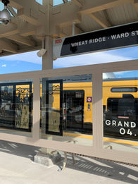
Blue Columbine is less than a mile from the G Line light rail station which takes you to Union Station in 27 minutes. You can also ride it to Old Towne Arvada for a fun meal or shopping—which is only two stops away.
Quick access to 1-70 is also close by.
Nuestro sitio se encuentra a poca distancia a pie y en automóvil de una serie de excelentesescuelasincluyendo Escuela del valle alpino y se sienta dentro delDistrito escolar del condado de Jefferson.
See what else is nearby
The 44th Avenue Subarea Plan
The subarea planning process concluded with a public hearing on April 24, after which City Council approved and adopted the 44th Avenue Subarea Plan.
West 44th Avenue is one of the City's primary east-west corridors, and the 44th Avenue Subarea Plan will provide a long-range planning document for the western portion. The plan focuses on W. 44th Avenue between Youngfield Street and Clear Creek (near Field Street) and will more broadly include the portion of the City between Clear Creek and I-70. This western segment of W. 44th Avenue is not simply a corridor; it is the connection between the eastern and western portions of the City, for the transit-oriented development (or TOD) at Wheat Ridge Ward Station, for Clear Creek Trail, for the Clear Creek Crossing development at the City’s far western edge, and for numerous adjacent residential neighborhoods.
Per community input gathered through the recently updated Neighborhood Revitalization Strategy and the ongoing Let’s Talk resident engagement program, the community wants to see improvements made to the aesthetic of its primary corridors, and W. 44th Avenue is a priority among those.
Today, W. 44th Avenue has a mix of conditions that create a unique context for future planning and redevelopment. Although the sidewalks, curbs, pavement, and lighting in the public right of way are in fairly good condition, there is, broadly speaking, inconsistency in private property investment and maintenance that undermines the overall visual appeal of the corridor. The City has taken some important steps, such as updating the Streetscape Design Manual to require trees along the street behind the curb, among other improvements, to enhance the overall user experience along the corridor, and enhancing the corridor will be a key part of this subarea plan.


